
The capital city, Addis Ababa, is located in the Entoto range
of the western plateau. Northwest lies Ethiopia's largest body of water, Lake
Tana. The or Blue Nile river, Ethiopia's greatest river and the chief tributary
of the Nile, begins at Lake Tana and flows through the plateau's western section.
The eastern or Somali Plateau section includes the Mendebo and Ahmar mountain
ranges, and a semi-arid region called the Ogaden. The plateau area is called the
dega (cool) zone: temperatures can drop to freezing during winter. Rainfall
is less plentiful than on the west side, and growing crops more of a challenge.
The plateau drops off on all sides to hot lowlands (the kolla areas).
In the northeast is the Dnakil Depression, a desert area that is one of world's
hottest places in the southwest.
Ethiopia is famous as the country of "13
months of sunshine." The Ethiopian year is based on the Julian calendar,
which has 12 months of 30 days each and a 13th month called Pagume, which
has five days (or six in a leap year). In general apart form the historical sites
Ethiopia has also immense wealth of natural attractions. Ethiopia has one of the
most captivating natural environments in the whole of Africa, captivating the
visitor with sights as wonderful as they are varied.
The Breath-taking
landscapes remain as unspoilt now as on the days of formation. The immense variety
of wild life remains wild and free unaccustomed to and unthreatened by man. This
part of the country offers tremendous opportunities for all visitors and especially
of particular interest of the area.
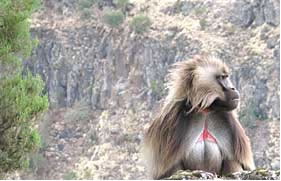
NATURAL ETHIOPIA
Ethiopia has varied and spectacular landscapes. Most of the country consists of an enormous plateau more than two kilometers above sea level. The plateau has mountains over 4,500 meters high and some of the world's deepest canyons. Fertile areas called tablelands are used for agriculture and livestock rearing. The Great Rift Valley, an earthquake fault line traversing Africa, runs from northern to southern Ethiopia and splits the plateau into west and east sections. The western section, called the Amha Plateau, includes the Simien, Entoto and Choke Mountains; Ras Dashen, at 4,543 metres, is the country's highest peak. The majority of the population lives on the Plateau, which constitutes the country's weina dega or temperate zone. Temperatures are pleasant, averaging 15° to 20°C.
The following are listed as the major potential sites for the natural attraction of the country.